Relying on old maps is like high-stakes gambling. Telecommunications service providers are a critical part of our overall infrastructure, so it’s important that they have a reliable source of information. Sitting at the crossroads of telecom, retail, and location-based services, a geographic information system (GIS) serves as a multi-layer solution for network planning and deployment, maintenance and operations, and market analysis.
Read on to discover how GIS for telecommunications, as one of the world’s most significant location intelligence markets, provides practical solutions for making data-driven decisions.

What is GIS in telecommunications?
A geographic information system, or GIS, comprises computer hardware, software, and geographic data for capturing, analyzing, displaying, and managing geographically referenced information (also known as spatial data).
A GIS application links different types of data to a location on a map, showing spatial relationships and patterns. Simply put, GIS software manages, analyzes, represents, and enriches location-related data. Using GIS, you can browse different location-based data sets as separate map layers to see your data in context. GIS helps to reveal relationships between different kinds of data related to a particular location.

The role of GIS in telecommunications is hard to overestimate, as it shapes the modern business landscape for telecom providers. Telecom providers use GIS for three reasons:
- Streamline workflows: GIS enables telecoms to modernize workflows with custom solutions for the field and office.
- Informed decision-making: GIS leverages the power of location data to provide a foundation of geospatial awareness and intelligent decision-making.
Collaboration: GIS allows technical and business stakeholders to engage, collaborate, and share with easy-to-use maps and apps.
According to Prescient & Strategic Intelligence, GIS in the telecom market was responsible for $1,564.6 million in revenue in 2021 for communications service providers (CSPs) globally. Prescient & Strategic Intelligence expects telecom companies to have $4,482.8 million in revenue by 2030, increasing at a CAGR of 12.4% between 2021 and 2030. Demand for network installation and the growing use of GIS for broadband and mobile services are expected to be among the key triggers of this growth.
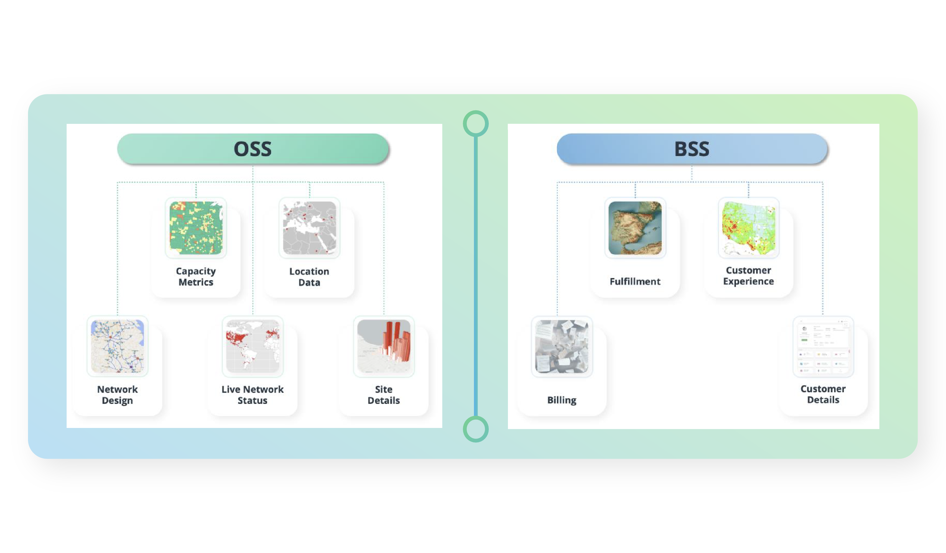
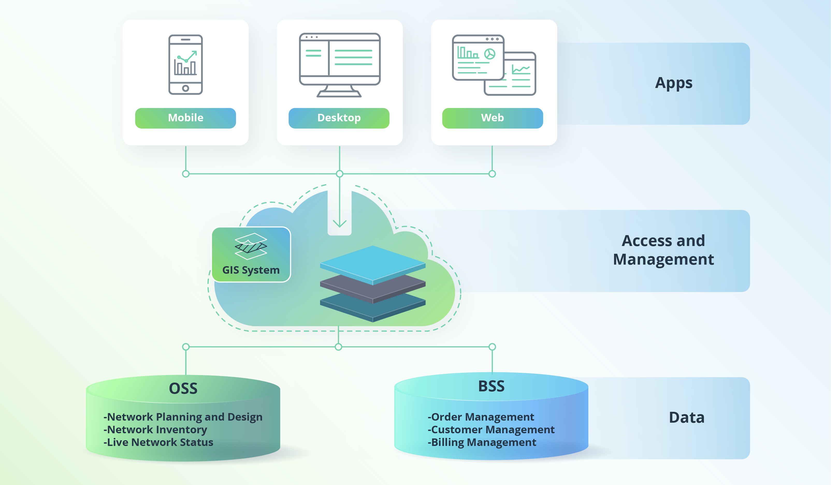
Telecommunications providers turn to GIS to combine data about operations support systems (OSS) and business support systems (BSS) with data on customer demographics, topography, population density, and projected population trends. OSS-related data includes capacity metrics, location data, network design, live network status, and site details. BSS-related data relates to the customer experience, billing, service fulfillment, and customer details.
GIS is also widely used at the crossroads of telecommunications, retail, and location-based services (LBS), making it possible to get 360-degree customer view solutions.
GIS also helps in gaining market share and retaining key customers with the help of spatial data to identify market demand for retention, upselling, and cross-selling. Telecoms can also use location intelligence to define major customer segments within business intelligence activities. GIS also helps to improve B2C marketing campaigns with social, economic, and demographic data.
Also, GIS modeling might be applied for small-cell deployments to develop innovative wireless network planning solutions for extending 5G coverage.
Yet these are not all of the ways that telcos can benefit from GIS.
How do telecom companies use GIS, and what benefits does it bring?
Today, GIS in the telecom industry can resolve various business challenges, from network planning and resource optimization to customer experience and analytics services. Here are major applications for GIS within the telecommunications industry and the benefits they bring.
GIS in network planning & deployment
GIS in network planning and deployment is about identifying market opportunities, assessing existing capacity, and maximizing return on investment (ROI) for telecom organizations. Capacity planning involves managing network resources, designing activities to add capacity when the need arises, and predicting network behavior or usage of value-added services.

In general, network planning in telecom is focused on three major components:
- Topological design — defining where to place network components and how to connect them
- Network synthesis — deciding what size of network components to use
- Network realization — meeting capacity requirements and maintaining network reliability
After network planning comes network deployment, which involves spreading networks across large territories. With GIS, everyone in a team can track deployment progress and communicate effectively.
Using a geospatial system during the decision-making process for network planning and deployment eliminates the risks of network congestion, outages, and bottlenecks. Also, telecommunications providers can apply geospatial infrastructure to improve network usage while reducing the number of idle resources.
Yet, telcos are not only using GIS to get ready for expansion through telecom network deployment. GIS is an essential tool for keeping existing infrastructure up and running.
GIS in maintenance & operation of existing infrastructure
Besides network planning and deployment, intelligent decision-making empowered by GIS analytics software enables resource and network optimization and 24/7 situational awareness. Using GIS data collected remotely through GIS applications, network engineers can fulfill tasks with a minimum of in-person visits.

In short, GIS for maintenance and operations in telecommunications serves four critical subdomains:
OSS/BSS (operation/business support systems) integration
GIS and OSS/BSS integration are used for billing and network management systems and customer relationship management (CRM) systems. Integration also boosts efficiency in sales and support through real-time situational awareness of status, network availability, and scalability.
Network operations and maintenance
Integrating OSS and BSS with location intelligence helps telecoms to deliver network stability for new fixed or wireless line service planning. GIS solutions provide real-time awareness and help to solve incidents quickly.
24/7 situational awareness
Additionally, GIS provides real-time operational awareness using web dashboards representing network connectivity and capacity, live status, and the environment around infrastructure This is how telecommunications providers can accurately estimate the time needed for restoration, reduce churn, and increase customer satisfaction. Moreover, real-time situational awareness increases safety.
Resource and network optimization
GIS provides visibility to assist decision-making, reduces costs, and leads to more efficient use of network assets. Thanks to location intelligence, telecom providers can optimize workflows (e.g., analyze the suitability of fixed-line planning). Location intelligence also helps telecom providers to optimize field operations by representing gathered information about the network, job details, customers, etc.
GIS for sales & marketing
In addition to its role in telecom market analysis, coverage, market demand, community and customer engagement, GIS is also an effective tool to locate areas with growth potential and upselling opportunities. This becomes possible by combining existing marketing and sales data with spatial analytics.

GIS for sales and marketing is especially beneficial for analyzing the market, determining coverage and market demand, and enabling community and customer engagement:
Market analysis
GIS helps companies in the telecommunications industry to qualify customers quickly by leveraging customers’ geographical data. Location intelligence comes in handy for market analysis, from service qualification analysis to retail analysis.
Coverage and market demand
Using detailed demographic datasets and location analytics, location intelligence can improve geotargeted marketing campaigns.
Community and customer engagement
Telcos are using GIS for live geographical monitoring of their net promoter score (NPS) and customer satisfaction rates to have a better demographic portrait of their customers. Your marketing and sales teams can make efficient decisions by providing location information from GIS systems.
Fiber-optic network deployment with cloud GIS
Increased deployment of broadband architecture (fiber to the home (FTTH), fiber to the premises (FTTP), fiber to the curb (FTTC), and fiber to the building (FTTB)) have escalated the demand for fiber-optic network development.
Growing internet penetration and data traffic, an increasing number of data centers globally, and high bandwidth demand are the key drivers of optical fiber market growth. The optical fiber market is expected to grow at a CAGR of 10.9% from 2022 to 2027, from US$4.9 billion in 2022 to US$8.2 billion by 2027 according to ResearchAndMarkets.

It’s no surprise that GIS also helps to identify inadequate fiber optic infrastructure and network gaps, reveal opportunities for communication service providers, and define resources already available in an area. Moreover, location intelligence can effectively assess how competition and environmental factors impact network development. To illustrate this, let’s look at real-life examples.
One of our clients is a German vendor delivering consulting services and software solutions to implement telecom networks for communities, municipalities, and businesses. The client wanted to enhance their software suite to improve the planning, design, and management of fiber to the X (FTTX) projects. FTTX encompasses optical fiber deployment projects, such as fiber to the home (FTTH), fiber to the antenna (FTTA), fiber to the building (FTTB), and fiber to the curb (FTTC).
We took on the challenge and developed a solution powered by cloud-based ArcGIS technology from Esri. Our solution allowed for creating map-based network architectures, selecting optimal network hardware, generating schemas for existing plans, and evaluating project costs.
Cloud-based GIS optimizes every step of fiber network deployment. It centralizes all data engaged in the process and makes it possible for all stakeholders to make changes in real time. This decreases risks and errors and improves team communication.
Cloud GIS solutions often come with native mobile applications and can be accessed via a browser or app. Cloud GIS brings excellent GIS data management, a quick data capture process, and little room for errors.
The Intellias method: GIS for telecom in full gear
Identifying opportunities for operators and potential risks costs a lot in the telecom sector. That’s why at Intellias, we’re constantly strengthening our expertise in GIS for telecommunications. Using GIS, telecom stakeholders can make better decisions, enhance team communication, and streamline workflows.

Network planning and deployment for efficient scalability
Building and designing networks is challenging. However, by leveraging remote engineering, communications service providers (CSPs) can reduce their time to market. At Intellias, we have developed tools and techniques to help telcos define market opportunities fast and evaluate existing capacity to maximize their return on investment.
Whether working with greenfield projects, updating existing networks, or simply evaluating revenue potential against legacy networks and capabilities, CSPs need trusted technology partners.
Let’s move to some more real-life examples from our practice. One of our recent GIS for telecommunications projects is related to developing wireless network planning software to enable efficient 5G coverage extensions using GIS modeling for small-cell deployments.
A successful US-based startup providing innovative 5G network planning and extension solutions for Tier 1 telecom operators asked us to contribute our GIS for telecom expertise. We have transformed a concept into a full-fledged product with full-cycle development, from design through implementation, testing, and deployment.
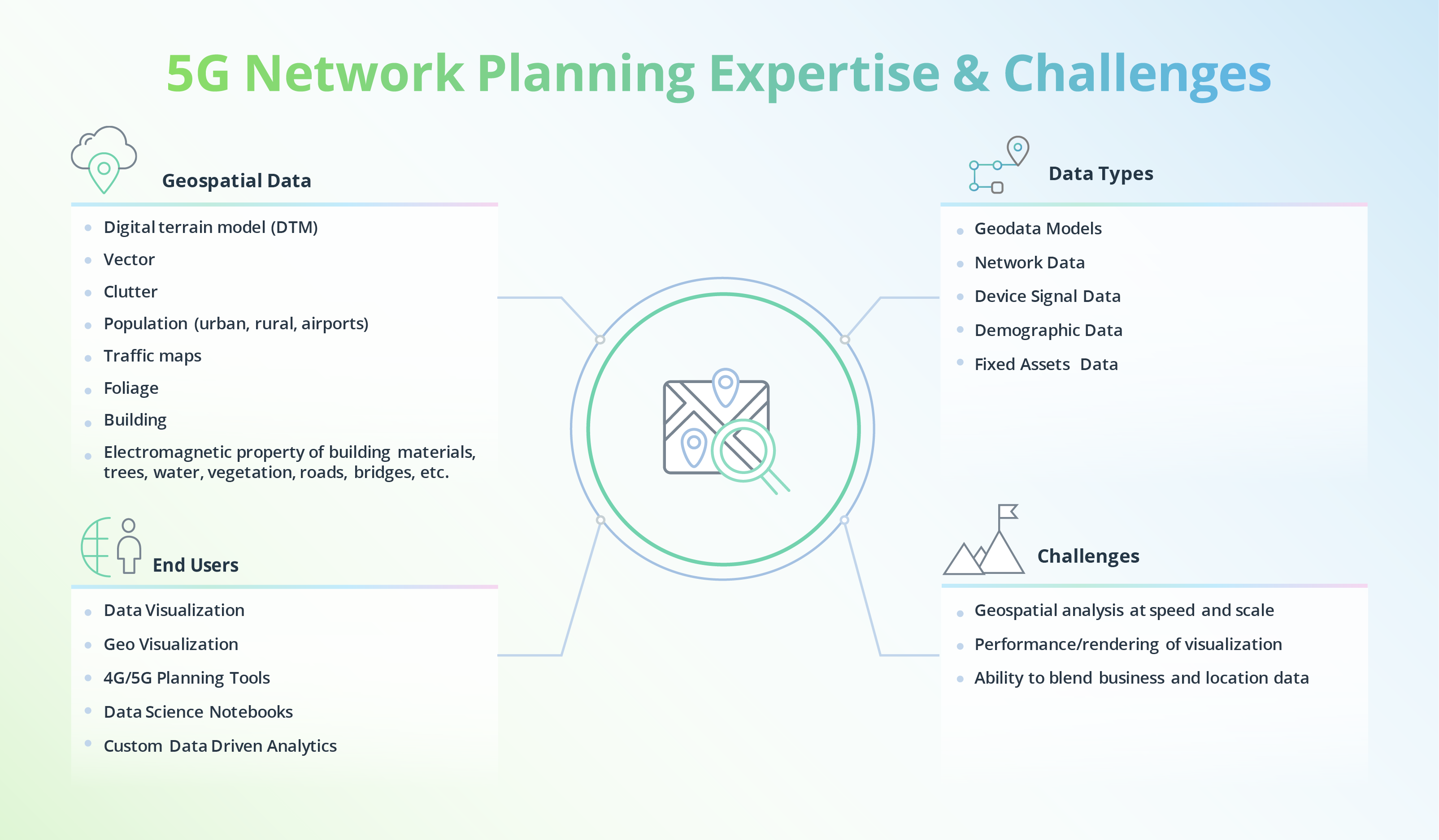
While working with 5G planning projects, we can juggle different data types (geodata models, network data, device signal data, demographic data, etc.) to develop the required solutions. See more details in the infographic below: Boosting cost-efficiency of 5G roll-outs
Operations and maintenance to increase profit
GIS solutions also help CSPs in gaining real-time situational awareness and solving incidents quickly. By integrating GIS with operations support and business support systems, telcos and CSPs can access web-based dashboards and conduct network suitability analysis for planning new services.
We successfully resolve challenges for our clients using geospatial data, data models, such as digital terrain model (DTM), vector and cluster data, demographic data. We also use traffic and building maps. We can deliver geospatial analysis at speed and scale, provide insightful visualization solutions, and generate aha moments by combing business and location data.
One project we’ve worked on involved developing web applications evaluating network capital expenditures (CapEx) and increasing profit using historical network analytics and location data. Our client was transforming their business model and needed an effective expense management solution.
Our solution shows network capacity rollout, the potential impact on incremental revenue growth, and the time and cost required. The solution developed flexibly leverages data from different sources, performs automated analysis, makes AI-based predictions, and automates rollout schedules.
Geographic information system (GIS) for the telecom sector: Mapping your way to success
GIS will make telcos aware of many aspects of modern telecom solutions. Location intelligence solutions have proven efficient in network planning and deployment, maintenance and support, and sales and marketing.
To stay efficient and innovate in today’s telecom industry, you need a GIS solution that lets you move forward at full throttle. By working with professionals, you can avoid making mistakes when trying new things. Intellias experts are a good fit if you need expertise in GIS for telecommunications.
Contact us to make the most of geographic information system (GIS) technology for telecom and discover new business horizons.