Geospatial data and its intelligent analysis have revolutionized various industries, including telecommunications. In an era when location information holds immense value, geospatial data empowers telecom companies with vital insights that drive decision-making, enhance efficiency, and foster sustainable growth. To embark on this transformative path, it’s crucial to understand the fundamentals: What is geospatial data? What is geospatial intelligence? And when does geospatial visualization come into play?
What is geospatial data?
Geospatial data, or spatial data, refers to information associated with specific geographic locations. By associating objects, events, and real-world phenomena with precise geographical coordinates defined by latitude and longitude, geospatial data enables their mapping. For instance, GIS data could be used to identify a car’s location when parked or to dynamically monitor its movement.
Geospatial visualization transforms spatial data into visually engaging representations such as maps and 3D models. This technique combines data from multiple sources to provide a comprehensive understanding of a particular location. Scientists leverage variables such as soil quality, water quality, and temperature data to identify areas with the highest agricultural yield potential, unraveling crucial insights about how people interact with the natural environment.
Geospatial visualization goes beyond static data maps, utilizing advanced technologies to create interactive 3D maps and graphics. These dynamic visualizations unveil patterns, trends, and themes on the Earth’s surface, facilitating deeper comprehension of our surroundings. With this powerful tool, decision-makers gain insights into environmental management, urban planning, disaster response, and more.
At the core of leveraging geospatial data lies geospatial intelligence — a multidimensional concept encompassing the collection, analysis, and interpretation of geospatial data for informed decision-making. Geospatial intelligence combines geographic data with other forms of intelligence, such as imagery, signals intelligence, and human intelligence, to provide accurate representations of locations and their physical environments. It plays a vital role in military planning, emergency response, and environmental management, enabling identification of patterns, assessment of emerging trends, mitigation of risks, and data-driven decision-making. Through examples of geospatial data such as mapping objects, events, and phenomena to specific geographical areas, geospatial intelligence unlocks valuable insights for a wide range of industries and applications.
In this article, we explore the pivotal role of geospatial data in the telecom industry, uncover real-world use cases, and highlight how organizations like Intellias can support GIS data projects and drive them forward. Join us on this enlightening journey as we unlock the power of geospatial data, mapping the way towards sustainable growth for telecom in the digital era.
Alliance of GIS and telecom
The synergy between geographic information systems (GIS) and the telecom industry holds immense potential for driving innovation and efficiency. By harnessing the power of GIS technologies, telecom companies can unlock a wide array of benefits, leveraging geospatial data examples that enhance accuracy, reduce costs, increase safety, and optimize resource management. This powerful alliance paves the way for success in the telecom sector, where geospatial data plays a crucial role in mapping objects, events, and phenomena to specific geographical areas, enabling informed decision-making and propelling sustainable growth in the digital era.
Synergizing GIS and telecom: a recipe for success
Geographic information systems and the telecom industry form a powerful alliance that unlocks a plethora of benefits. By synergizing GIS technologies with telecom infrastructure, businesses can optimize operations, enhance decision-making, and achieve remarkable success. The integration of GIS and telecom enables seamless spatial data management, analysis, and visualization, offering a comprehensive understanding of the physical world and its interconnectedness.
Through the conjunction of GIS and telecom, organizations gain access to a wealth of accurate and up-to-date geospatial data. This data, derived from advanced technologies such as the Global Positioning System (GPS), lasers, and remote sensing, serves as the foundation for digital maps and 3D models of geographic locations. The accuracy provided by geospatial data proves invaluable for various applications, including precise navigation, efficient asset management, and comprehensive risk assessment.
Unlocking benefits for telcos: accuracy, cost reduction, safety, and efficiency
Businesses utilizing geospatial technologies in the telecom sector can reap numerous benefits, yielding a significant competitive advantage.
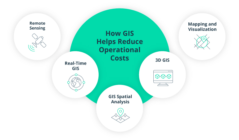
Improved accuracy: Geospatial data systems, relying on cutting-edge technology, ensure accurate data collection. By harnessing GPS, lasers, and remote sensing, telecom companies can generate precise digital maps and 3D models. This heightened accuracy enhances navigation systems, enables effective asset management, and facilitates robust risk assessment.
Reduced costs: Geospatial technologies offer substantial cost-saving opportunities. By automating data collection processes, telecom companies can streamline operations and reduce mapping and surveying expenses. Additionally, the implementation of geospatial solutions optimizes resource allocation, asset management, and operational efficiency, resulting in tangible cost savings.
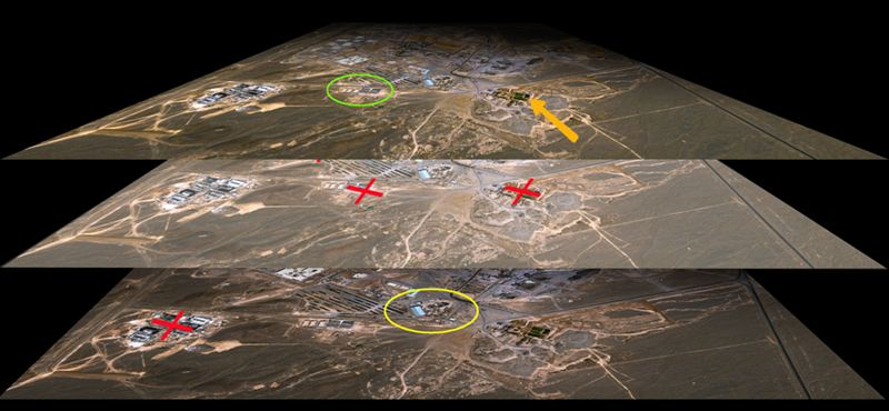
Increased safety: Geospatial data plays a vital role in enhancing safety measures within the telecom industry. By constructing 3D maps that highlight risks and hazards, companies gain a comprehensive understanding of their environments. Real-time monitoring and alerts enable swift responses to emerging issues, whether caused by weather conditions, traffic congestion, or natural disasters, ensuring the safety of both assets and personnel.
Efficient resource management: Geospatial data enables efficient resource management by providing insights into availability, allocation, and utilization. Telecom companies can leverage spatial analysis to make informed decisions about resource allocation, ensuring optimal resource use and minimizing waste. Moreover, geospatial data supports the monitoring and management of natural resources, including water bodies, forests, and wildlife, fostering sustainable practices.
By embracing the alliance of GIS and telecom, businesses unlock a range of benefits including improved accuracy, reduced costs, increased safety, and efficient resource management. These advantages empower telecom companies to make informed decisions, enhance operational efficiency, and pave the way for sustainable growth in the digital era.
Boosting cost-efficiency of 5G roll-outs
Discover showcaseGeospatial data: a catalyst for sustainable telco development
Optimizing telecom networks extends beyond the implementation of new technologies like 5G. To ensure success, telecom companies must focus on analyzing and optimizing their existing networks, leveraging spatial data examples to gain deeper insights into consumer behavior. By harnessing new location data streams, telecom companies can uncover valuable spatial data that informs long-term network planning, facilitates strategic marketing, and drives capability building for sustainable growth.
As 5G networks grow increasingly complex, the importance of accurate and detailed geospatial data becomes paramount. Renowned for their data transmission capacity and low latency, 5G networks serve as the backbone of future technologies and smart cities. This advanced wireless standard facilitates seamless communication among countless devices, sensors, and infrastructure objects, enabling intelligent systems to make informed decisions and effectively manage daily operations within smart communities.
For the telecom industry to harness the full potential of 5G and meet the demands of future technologies, it must integrate both geospatial and big data into its processes. The assimilation of geospatial data in telecom is equally crucial for upgrading existing networks and providing enhanced services.
Geospatial data acts as a catalyst for telecom providers’ sustainable development, enabling comprehensive network optimization, strategic decision-making, and seamless integration of emerging technologies. By leveraging the power of geospatial data and exploring examples of spatial data, telecom companies can stay ahead of the curve, gain valuable insights, deliver superior services, and pave the way for a digitally connected future.
Realizing the impact: geospatial use cases in telecom
Discover the transformative power of geospatial solutions in the telecom industry through two compelling use cases from Intellias. In these real-world examples, Intellias showcases expertise in developing advanced location-based technologies that optimize operations, enhance network planning, and revolutionize infrastructure management. Explore how Intellias leverages geospatial data (including geospatial databases) and GIS-driven solutions to drive efficiency, accuracy, and growth in the telecom sector.
Enhancing location-related data visualization

Intellias revolutionized a location-related data visualization service, reducing the release time to market from 1.5–2 hours to just 25–40 minutes. The team has been actively involved in the development of a cutting-edge 3D geospatial visualization and location-based data analysis API toolkit. By adopting an Agile Kanban methodology and overcoming challenges related to the client’s unique IT infrastructure, Intellias optimized deployment and production validation processes.
To further elevate the service, the team implemented innovative technical solutions, including hexagonal heatmap visualization and data processing optimization using Hilbert curves. This collaboration has not only addressed the client’s specific needs but has also unlocked new business opportunities, allowing the client to expand their product offerings and seamlessly integrate 3D GIS visualization services. With a focus on securely storing, transforming, and filtering location-related customer data, the client’s objective is to provide insightful information through immersive 3D geospatial visualization.
Revolutionizing network cable mapping: Intellias’ GIS-powered solution

Intellias harnessed the power of GIS to develop an advanced telecom cable location solution, streamlining network planning and management processes. By leveraging Agile and Extreme Programming (XP) methodologies, we created a software tool that automates fiber-optic project planning, design, and execution. With ArcGIS products facilitating map rendering and storage, the solution optimizes FTTx network designs using clusterization and heuristic algorithms.
Our collaboration achieved remarkable results, including greater automation of FTTx network design, precise cost estimation, optimized cable and duct routes, and fiber-level design capabilities. The solution featured a comprehensive web-based project management portal for network project monitoring, along with a mobile application for infrastructure documentation. This successful partnership solidified Intellias’ reputation as a trusted outsourcing partner, enabling our client to improve their market position, enhance their services, and expand their offerings.
Partner with Intellias for your GIS data projects
When it comes to GIS-based software development and location services, Intellias boasts extensive expertise spanning various industries including transportation, logistics, retail, real estate, finance, and government. Our dedicated team of GIS engineers excels in creating customized GIS mapping solutions tailored to meet specific business needs. With a comprehensive range of geospatial and GIS development capabilities, including geospatial data analysis, we are well-equipped to support your GIS data projects from start to finish.
Intellias leverages its expertise in GIS software integration and collaboration with leading services such as ESRI ArcGIS/QGIS, Google Maps, Bing Maps, HERE, and Mapbox to develop custom business maps that integrate robust databases. We simplify the process of data capture and conversion, allowing you to effortlessly transform physical maps, survey coordinates, and other data sources into valuable geographic information.
Our geoprocessing and geocoding capabilities enable automated and manual data transformations, ensuring accurate and precise mapping of addresses, landmarks, and points of interest. With our GIS database design expertise, we can create and integrate large spatial databases using popular platforms such as Microsoft SQL Server, Oracle, and PostgreSQL with PostGIS, enabling seamless data conversion, geocoding, and geographic editing.
Intellias also excels in 3D GIS services and modeling, offering our clients detailed and interactive 3D models of landscapes that can be rendered in a map interface, providing limitless layers, symbols, and styles. Additionally, our GIS consulting and training services provide technical and business experts who specialize in project management, Agile development, roadmap planning, and GIS database administration. We empower your organization to enhance its GIS expertise and make informed decisions through our comprehensive support.
By partnering with Intellias for your GIS data projects, you gain access to our extensive knowledge and experience in GIS software development, geospatial analytics, and cloud infrastructure. We are committed to delivering tailored solutions that align with your business objectives and enable you to unlock the full potential of your geospatial data.
Choose Intellias as your trusted GIS partner and let us help you navigate the intricate world of geospatial technology, providing you with the expertise and solutions you need to succeed in your GIS data projects.
Bottom line
Geospatial data and analytics play a crucial role in the telecom industry, fueling sustainable growth in the digital era. By leveraging geospatial technology and harnessing the power of geospatial analytics, telecom companies can optimize their operations, improve network efficiency, and enhance customer experiences.
The use cases presented by Intellias demonstrate practical applications of geospatial technology in optimizing telecom operations. From location-related data visualization services to GIS-driven solutions for network cable mapping, these examples showcase the tangible benefits that telecom companies can achieve by embracing geospatial insights.
Looking ahead, it’s clear that geospatial data will continue to be a catalyst for sustainable telecom development. As 5G networks become more complex and interconnected, the need for accurate and detailed geospatial data will intensify. Geospatial technology will serve as the backbone for future technologies and smart cities, enabling seamless communication among devices, infrastructure, and intelligent systems.
To embrace a sustainable digital future, telecom companies must recognize the immense value of geospatial data and invest in its integration and analysis. By partnering with experts like Intellias who possess extensive expertise in GIS-based software development and location services, telecom companies can unlock the full potential of geospatial data and gain a competitive edge in the industry.