How much time do you spend figuring out the transportation system in a new city? Or more precisely, when do you throw in the towel and decide to walk, bike, or hail a taxi instead of using public transport?
Urban transportation systems in big cities appear mazy and hazy for new visitors. But oftentimes, even born-and-bred residents struggle to understand their complexity. Especially when connections between different options are hard to figure out. Subsequently, more cars crowd the streets, while already subsidized public transportation grows less profitable to operate.
Now the bigger question is this: What would it take to create seamless multimodal transit? An experience so good and effective that people favor public transport over private cars. We have some ideas on how to achieve this.
What is multimodal transportation?
Multimodal transportation assumes using two or more transportation modes to move people or goods from door to door. A multimodal transportation system can coordinate either urban mobility — the smart movement of people using private and public modes of transport — or commercial logistics — the movement of freight and cargo using different modalities.
A better way: Connected, door-to-door journeys
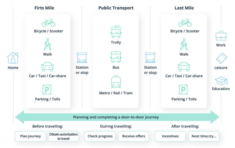
Source: Visa — Transforming Urban Mobility
Why better multimodal planning is needed
As Mattafix once sang about Big City Life: “Pressure nah ease up no matter how hard me try.”
Although the song is from the early 2000s, urban planners in major cities can still relate to it. Despite continuous effort, heavy traffic, pollution, and crowding in public transport remain stress-inducing issues for local authorities.
Unless transformations happen, an average urban dweller will spend 106 hours per year in traffic jams by 2050 — three times more than today.
The above is the worst-case scenario. There is some better news too. Cities around the world have already made tremendous progress in improving the quality, availability, and efficiency of urban transport.
The same ADL Global study rates most of the world’s 50 largest cities as having achieved two-thirds the level of urban transportation performance that could potentially be reached today. The global leaders are Hong Kong and Amsterdam.
So what’s needed to go the rest of the way? Cities need to devise and implement a better multimodal transportation plan.
A multimodal transit plan is one that takes various modes of transport into consideration (walking, cycling, public transit, cars, etc.) and builds convenient connections between them.
Creating such a continuous flow allows planners to redistribute passengers across different nodes, leading to:
- Less use of individual motorized transport
- Less public transport crowding
- Reduced traffic congestion
- Diminished urban pollution
- Higher revenues for public transport companies
That’s a ton of good stuff. But people won’t drop cars unless they have a faster and easy-to-access alternative. The goal of multimodal transportation planning is to give them such options.
Multimodal transportation system: the main tech elements to get right
Multimodal urban transportation planning requires tools for evaluating the quality of each transport mode — public, private, and shared.
One of the standard measurements city planners love using is LOS (level of service), which assigns an A to F ranking to each mode. But the problem is that this standard was invented almost 50 years ago. It no longer reflects the reality of urban transportation systems.
LOS is a car-centric metric aimed at prioritizing the smooth movement of individual vehicles rather than a harmonized flow across multiple modalities. When making an assessment using this standard, a single-occupancy car counts the same as a bus with 50 people. You already sense some issues here, right?
But if LOS is to be tossed, how should we approach urban transportation planning? By thinking in different layers and by analyzing dimensional data.
A multimodal transportation plan (and the tech systems to power its execution) has to analyze how different journeys can be best fulfilled using a range of transportation means. Next, such multimodal transportation solutions should help you model multiplex configurations of convenient transport hubs and provide analytical data for decision-making.
To help you better understand how such a complex, comprehensive system could function, let’s take a look at its main elements.
Intelligent transportation system
An intelligent transportation system is a control panel used to plan, manage, and optimize transportation across different modalities.
Every city has one. But the problem is that they rarely cover all modes of transport. Some only govern street traffic and public transport. Others also offer passenger-facing services.
To deliver multimodal routing, such systems may need to provide full visibility into:
- Transportation management. This covers all available modalities, from buses and urban rail lines to taxis and carsharing/bikesharing schemes.
- Traffic management. This involves a collection of tools, processes, and infrastructure that allow you to manage the situation on the roads.
- Traveler services information and payments. This passenger-facing unit handles personal journey planning, point-to-point navigation, and payments for transportation services.
- Connected infrastructure. Sensors and hardware collect transport data and enable remote control.
When you have data from each of the above systems, you are in a good position to start designing a multimodal transportation plan.
Big data analytics
Seamless multimodal transportation is hard to implement because planners lack proven data for decision-making. Essentially, that’s why we talked about integrating disparate transport systems in the first place.
At present, urban planners rely on easily quantifiable metrics such as operating costs or travel time instead of analyzing the wider operational context:
Impacts considered and overlooked
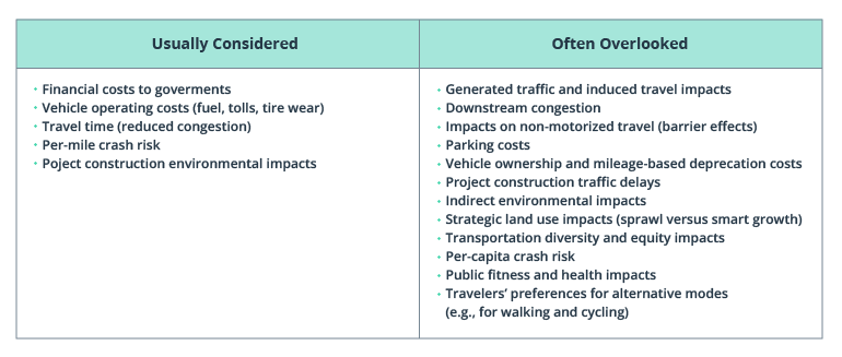
Source: Victoria Transport Policy Institute — Introduction to Multi-Modal Transportation Planning
Since limited data is available, some routes are falsely labeled as “unprofitable” or “unpopular” and get deprecated. But there’s one major caveat: public transportation doesn’t become more effective or profitable when low-profit routes are removed.
A 2020 study by the Singapore-MIT Alliance for Research and Technology analyzed transport data in Chengdu, China. Unsurprisingly, ride-hailing services cannibalized around 33% of public trips and up to 40% during peak hours.
But the bigger finding was this:
Predefined and non-responsive transit schedules feature a small number of profitable routes which are required to offset losses from a larger number of unprofitable routes operating in underserved areas. Dynamic and responsive ride-hailing services have gained the most traction in these profitable route zones, leaving public transit to operate unprofitable routes in underserved areas.
Essentially, local transportation planners shot themselves in the leg — they worsened the service levels and didn’t recoup any profits.
Big data analytics helps prevent such flawed planning by allowing you to take more factors into
account — the daily flux in demand on popular routes, passengers’ price and time sensitivity, the impact of ride-hailing on traffic and pollution, etc. Having a wider array of data points not only helps you design effective multimodal routes (to encourage use of alternative modalities) but also to distribute profits more equitably between private and public players.
GIS data
Passengers will use public transport when it’s easily accessible. GIS tools can help you collect extra geospatial insights for determining transport accessibility and planning the layouts of multimodal transportation hubs.
For example, you can appraise city-wide transportation options using cost or time of travel as a comparative metric to identify underserved areas and gaps in transit journeys. Based on the collected data, you can then determine if it’s worth adding:
- New pedestrian or bike infrastructure
- Extra public transport routes
- Service coverage by a private company
For example, to plan new bus routes in Hanoi, Vietnam, a working group used GIS data to analyze:
- The current locations of bus stops
- City-wide bus route coverage
In each case, they measured how long a passenger had to walk to connect to public transport. They chose 500 meters and 1 kilometer as two markers for acceptable walking distances in different districts. Then they analyzed each bus line using these distance markers and flagged all residential buildings that weren’t within this distance. Effectively, these were blind spots where extra public transport stops should be added to increase network coverage.
With GIS data, you can run even more complex scenarios to model the positioning of different transport stops/hubs across different modalities including rail and subway.
Open APIs
Multimodal transportation is impossible to imagine without the mobility as a service (MaaS) component, offering travelers a roster of transportation options supplied by both public and private players.
Let’s be realistic: no city can establish an effective transportation system without involving private companies. Especially when there are so many types of providers on the market (and even more soon to come!).
Urban mobility business models
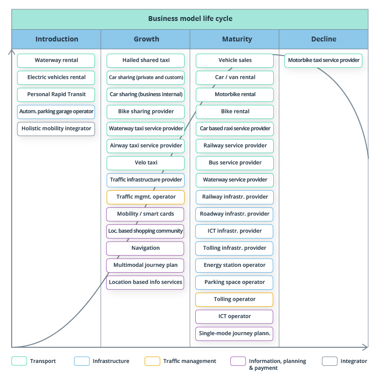
Source: ADL Future Lab — Future of Urban Mobility
The issue is that in many cases, private and public transportation exist in a state of not-so-friendly rivalry. Regulatory pushback over ride-hailing services continues, and there are ongoing debates over e-scooter regulations. Were they to appear in the future, flying mobility solutions would also fall under scrutiny.
But the truth is that the transportation market has room for everyone. What it lacks is a means to balance passenger distribution across different modes of transportation.
The way forward is switching to a platform business model. That means becoming an aggregator and orchestrator offering access to many transportation and supplementary services.
Assuming this position will allow you to:
- Increase ridership across lines
- Improve passenger service levels/satisfaction
- Earn extra revenue from partners
Such partnerships between city planners and private companies are already happening. For example, Atlanta has integrated Uber into its MARTA transit app so that commuters can easily switch between public and private transport. Mostly, ridesharing is used to bridge the last mile.
In Germany, the Volkswagen Group has made several deals with local authorities to integrate their WeShare e-share service and their MOIA electric shuttle service into urban transport operations.
To be successful, such partnerships require orchestration both on the operational and technical levels.
- Operationally, you have to know how you will govern public companies to prevent service cannibalization.
- Technologically, you need to integrate third-party solutions into your transportation systems.
For the former, you need better analytics and real-time transport planning capabilities. For the latter, platform development and API expertise are required.
User navigation application
When a transit app is inconvenient (or non-existent), you’ll struggle to get passengers on board (literally).
Many cities have transport planning apps. But far fewer provide end-to-end multimodal planning capabilities, from initial route building to real-time guidance through different modalities, with in-app fare payments included.
Even when you have a well-connected transportation system, people struggle to figure out how to best get from point A to point B without jumping through hoops. When personal journey planning is hard, most people will just take the car or hail a ride.
So prove them the opposite is true.
We recently helped one of our clients develop a system for processing real-time transit navigation data and built a companion app for passenger journey planning.
With this new app, users can build routes towards different points of interest and get navigation guidance for public transport (including real-time information on wait times) and walking routes. The app works both online and offline, and we are now working on integrating more MaaS options from private players.
A user-friendly navigation app is central to growing public transport ridership. Plus, it provides you with extra data on transport use (for example, passenger counts for different routes if integrated with a transport card). Additionally, when such apps are also integrated with traffic management systems, you can issue real-time alerts to users on traffic jams, route disruptions, and accidents (akin to Google Maps) and better regulate road traffic. Finally, such apps can later be used to introduce more complex traffic management solutions such as dynamic road pricing or city-wide parking management.
Integrated ticketing and payments
The last but not the least significant element of an effective multimodal urban transport system is integrated fare payments.
Public transport use is directly correlated with the convenience of payment. Take it from Hong Kong, a city with 2.9 smart travel cards per citizen. It’s also the city where car registrations, transport-related fatalities, and CO2 emissions are among the lowest in the world.
Making transportation payments convenient isn’t that hard either, as you have plenty of options:
- Contactless smart cards
- Payment card-centric ticketing
- Identifier cards or closed-loop tokens (codes)
- Account-based ticketing via a transport app
What’s more, switching to online transport payments comes with a number of monetary gains, as Visa reports:
- The operational cost of issuing a digital ticket is 4.2 cents for every digital dollar versus 14.5 cents for every physical dollar collected.
- Transport providers who opt for contactless payments can reduce fare collection expenses by 30%.
Finally, taking charge of payments can help urban planners incentivize public transport ridership — or the use of a particular transport mode you are seeking to promote (for example, e-bikes). That’s what Sydney authorities have been trying to do in a recent experiment with Opal digital cards:
From the middle of this year up to 10,000 Opal digital card users will be able to pay for an Uber, a fixed fare Ingogo taxi trip, or a Lime bike journey using their Opal card. If they then catch public transport within 60 minutes they will receive a credit to their Opal account of up to $3.
The above is a very smart way to help the general public develop a preference for multimodal urban transportation over private car use and end-to-end reliance on private services.
To conclude
Multimodal transportation planning is structurally and operationally complex. You need to have good connectivity between existing systems. Plus, you need to be able to build extra integrations for both internal and external data exchanges.
Good data is central for assessing the convenience, effectiveness, and attractiveness of different transport modes — the triumvirate of factors passengers expect from transportation service providers.
Once you get the initial infrastructure in top shape, you can experiment with more advanced (and revenue-boosting!) product development vectors such as partnership schemes with private mobility players, dynamic fare/road pricing, and passenger incentives for using greener transportation options.
Let’s chart your new multimodal transportation map. Contact Intellias to receive an in-depth consultation on the IT architecture and supporting technologies for developing a seamless passenger experience.