From maps that guide us around unknown places, we’re now getting maps that drive business optimization. Custom maps with layers that visualize critical data can help businesses optimize processes, improve mobility, get insights, and save resources.
Maps are breaking into the digital era in an absolutely new form. They’re evolving into fully fledged digital products and search engines valued by consumers and businesses. Two out of three customers look for information on local businesses using maps.
Information customers are looking for on maps
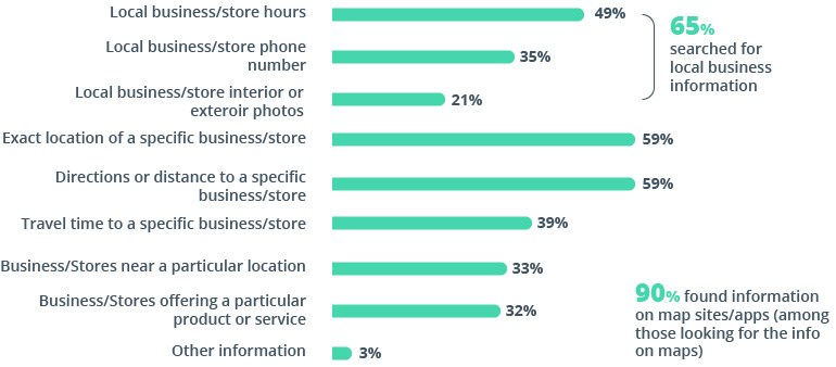
Source: Beaumonde, 5 Awesome Things Google Street View Does for Your Business
This high demand for maps has resulted in growing investment in digital mapping services. Apart from several giants like HERE, TomTom, and Google that provide maps for businesses, there are plenty of smaller technology solutions providers fighting for market share. Their products often compete by focusing on the needs of specific customers.
Growth of investment in digital mapping solutions
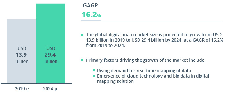
Source: Markets and Markets, Digital Maps Market – Global Forecast to 2024
Maps and products that rely on maps are becoming more complex. Today, maps rely on intelligent automation, geographic information systems (GIS), all-around data, and IoT connectivity to deliver greater value to users. Let’s find out what stands behind the common maps we use every day and see what business solutions rely on GIS, digital mapping, and GPS location information in the background.
Powerful sidekicks of digital mapping technology
For at least a decade, digital mapping systems have been drawing on a set of technologies that complement their already powerful functionality. Some of these technologies build a solid foundation for digital mapping, while others enhance maps with unique and customer-oriented features.
GIS in digital mapping for data gathering and multi-layer personalization
Geographic information systems provide a suite of tools and an entire ecosystem for collecting and processing geodata. GIS mapping can be enriched by combining open-source tools with a custom internal GIS solution to process spatial data in different formats and quickly convert data for specific needs.
GIS tools enrich maps with specific layers of information that aren’t available on traditional maps. For digital mapping, GIS tools gather data on traffic, vehicles, road restrictions, toll costs, and points of interest along the way. By combining and switching between layers, digital mapping solution providers can offer a wide scope of services for customers in various industries.
Machine learning for wider automation and greater customer convenience
After collecting a huge amount of data to place as a map layer, a mapping solution provider faces extensive manual work to label and structure that data. Automation comes in handy to accelerate map compilation and simplify use of the end product. Rendering a 3D model of a city or any landscape requires placing objects on the map that mirror real-life infrastructure. Automation using machine learning can help to label objects, classify them, group them in segments, and provide various views for easier city planning, construction, and road mapping.
By combining machine learning, GIS, and cloud technology, digital mapping can rely on 3D point cloud classification for faster rendering and to enable custom use cases for better urban mobility, logistics, and transportation. Accelerating object classification with automation tools can decrease rendering times from months to minutes while enabling end users to render map layers right in a web browser.
Location services to track and trace movements
Location services can do much more than locate lost mobile phones or track vehicles on maps. Geocoding thousands of data sets with the highest quality and accuracy allows end customers to plan smart routes excluding geofenced or restricted areas. Embracing location intelligence services that analyze thousands of data points gathered from robust API integrations can impact business-critical key performance indicators (KPIs). Knowing the exact place where your fleets lose the most time or fuel can help you save money and increase customer satisfaction with accurate ETAs.
The Internet of Things for collecting data and enhancing maps
The Internet of Things opens the world of hyper-connected and virtually tangible objects within cities. Digital twins technology combined with 3D mapping can contribute to the creation of precise city models. Thanks to the edge computing power of sensors installed on vehicles, road infrastructure, and aerial data collectors like drones and helicopters, map providers can perceive real-time representations of surroundings as live layers on self-healing maps. This time sensitivity opens up new opportunities for life-critical technologies like autonomous driving to rely on maps to safely navigate the road.
Mapping production process that drives better decisions
Building a map is all about getting the right data and using it fast. Mapping data pipelines can drive value and business-critical decisions. Mapping solution providers can cover several specific stages of map building and rely on map development vendors for advancing their map production. But what should a successful map production process look like? There are several critical phases that cannot be omitted. The process starts with data collection and ends with the development of a complete application or mapping solutions platform.
Gathering data
- Physically collecting data from sensors like Lidar, drones, and infrastructure
- Controlling data quality and ensuring readability of data formats
- Collecting data in the field and recognizing feature classes, raster data sets, and data tables
- Parsing, capturing, and grabbing data sets through API integrations
- Storing data depending on the chosen type of storage: data lake, data warehouse, data pipeline
Processing data
- Recognizing objects in aerial photos and satellite images
- Converting images to supported formats
- Ensuring compliance with NDS, ADASIS, SENSORIS, TISA, and other formats
- Validating data acquired from files with data formalization, advanced geospatial analytics, automation pipelines, merging and lipping algorithms, polygon simplification, labeling, flowcharts, and spatial relations
- Migrating and injecting data for improved database management, geocoding, geofencing, thematic layer creation, and terrain analysis
Compiling maps
- Optimizing map sizes, compiling data on maps, optimizing data pipelines and cloud infrastructure, testing maps
- Publishing maps; web mapping; distributing dynamic maps, 3d maps, and thematic maps for specific solutions
- Visualizing data on maps, web rendering, building vector and raster models
Developing SDKs and APIs
- Developing mobile and embedded SDKs/APIs and platform-based SDKs/APIs for custom mapping solutions for data visualization, advertising services, fleet telematics, tracking and tracing, visual dashboards, indoor and venue maps, routing, public transit, traffic management, and weather conditions
Developing components, apps, and platforms
- Creating complete solutions that offer custom maps with a scope of user-focused services accessible on mobile, web, and desktop depending on different user roles and required functionality
Moving through all these stages, maps become valuable business assets and tools to build future growth strategies. For example, logistics companies can rely on maps saturated with spatial data on roads, traffic, and weather for smart route planning, minimizing expenses, and preventing potential hazards along the route. Mobility providers can plan transit loads for passengers and transportation on schedule based on data on an area’s population and time for the raised demand for public transport. Agricultural businesses can use field maps to plan crop seeding and timely harvesting based on weather and the level of pesticides used. Local businesses can place their stores on maps as points of interest outside as well as within venues.
Digital mapping trends: from maps in hand to maps for business
Mission-critical automation of industries places challenges on map providers, who rely on advanced technology to gain a competitive edge and satisfy increased requirements for specific maps. In search of the next big thing in digital mapping technology, businesses may look at the following trends that underline the evolution of maps.
Crowdsourcing data
Modern maps are sensitive to the time they receive updates. Mission-critical systems like autonomous cars require data on road situations in the time frame of a few milliseconds. Fortunately, there are plenty of data sources around to provide fast updates for cars. Crowdsourcing data becomes possible thanks to a wide network of sensors on vehicles and infrastructure along the road as well as continuous communication between traffic participants.
Maps as a sensor
Sensor fusion is a recent concept that allows highly automated systems in cars and other machinery to comprehend the world around them in order to make the right decisions. Maps along with location modules are becoming key parts of sensor fusion technology. Automated machinery can rely on embedded digital maps to safely navigate and maintain critical functions.
Streaming maps
Static maps that receive updates once in a while are no longer relevant to customers’ needs. Digital mapping technology is evolving into dynamic content generators that receive huge loads of real-time data streamed from sensors.
Self-healing maps
Maps are becoming smarter. If a map recognizes critical gaps that prevent a car from safely using the road, it can automatically look for an update of the affected map area. AI and deep learning algorithms can identify and modify critical features in real time to initiate updates.
Computer vision and deep learning in mapping
Computer vision technology can recognize road signs and map them onto recent high-definition maps. It can even interpret images to choose the safest route. Deep learning algorithms can adjust a route to include a stop for charging an EV or just a coffee break.
Voice assistants navigate the road
While using maps, drivers shouldn’t lose their focus on the road. Speaking is the most convenient method for a driver to communicate with a navigation system. A voice assistant frees a driver’s hands and decreases distraction. Responsive maps complemented with voice assistants can accurately build routes and prevent potential incidents.
Cloud storage and processing
Today, maps rely on more computing power than ever before. Apart from always-on communication with an update center, a cloud provides flexible and reliable infrastructure for map development. DevOps practices can help with optimizing the map production pipeline and ensure timely and relevant map updates. With the introduction of 5G technology, cloud connectivity guarantees smooth streaming of map content.
HD maps and SLAM in mapping
Working with high-definition models of the surrounding environment, maps need to rely on fast systems that can process data in real time. Simultaneous Mapping and Localization (SLAM) algorithms can process accurate (within 10 to 20 centimeters) and dynamic 3D renderings of an environment, including slope and curvature, lanes, signs, and moving objects.
Incremental OTA updates for maps
Over-the-air (OTA) updates have become a key requirement for maps. Drivers need their maps up to date at all times. No one wants to visit a car dealership for map updates. Continuously streaming content is the only option today.
VR/AR as tools to find clues on maps
Virtual reality (VR) and augmented reality (AR) are penetrating many spheres of business. Navigation systems are already equipped with 3D maps, and the next step is augmenting those maps with VR/AR objects. This offers an immersive experience, especially if we’re talking about indoor maps of venues big enough to get lost in. VR/AR maps can guide users without any distraction, suggesting the right turn without hassle.
Nothing can stop the evolution of digital mapping
Mapping companies and industry-specific solution providers who are pioneering digital mapping technology are always in search of new steps in their engineering strategies. Recent advancements in map technology multiplied by users’ demands for putting specific data on maps leaves no choice but to turn maps into complete digital products. Maps now serve business needs as much as the needs of individuals navigating the streets.
If you’re on your way to building a custom mapping solution, want to enhance existing maps for your customers with specific data layers, or need GIS tools to structure and process extensive spatial data sets, Intellias is right around the corner — and the route is simple. Contact us and we’ll get back to you to discuss your mapping needs.