Today, cities are built very differently than they were just a few decades ago. Besides new materials and construction techniques, it is a completely new approach to urban planning that helps create thriving, safe, and power-efficient residential spaces around the world.
Urban planning has been around for millennia — in fact, for as long as human settlements have existed. City builders have always striven to optimize their design to facilitate transportation, logistics, and ease of access to the most remote corners of their cities. With the advent of modern technologies and the emergence of the concept of smart city infrastructure, urban planning has taken a tremendous leap forward.
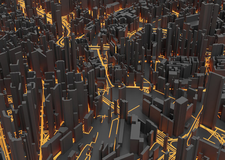
Smart cities have also been around for a while and we can now say with confidence that they are here to stay. What we are observing today is a rapidly proliferating trend of digital urban planning using high-precision simulations of existing or future cities based on real-time sensor data. This data is used to create exact virtual replicas of physical, brick-and-mortar cities — virtual twins.
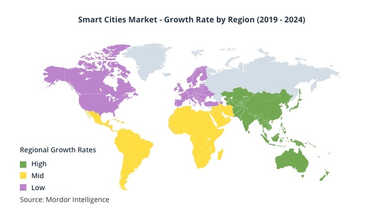
Source: Mordor Intelligence
Will the construction of a new major highway or subway line affect the life of nearby communities? Will a new multi-storey business center block the sunlight in a popular park? Would closing down a downtown road cause congestion on nearby streets and by how much?
Using the right tools and the right models, all of these questions can be answered before any real work commences. Let’s take a look at how modern ICTs redefine the urban planning landscape and help run what-if experiments in the virtual space.
What is a digital city?
The term “digital city” can be interpreted in various ways. On a broad scale of things, a digital city is one where both residents and municipal authorities enjoy fast, reliable, and convenient access to an array of city-wide information services unified under the umbrella of a single digital platform. These services address a variety of aspects of everyday life and work, starting from typical e-government functions to traffic, water and energy control, waste management, surveillance, public announcements, and much more.
These services are available 24/7 and are based on various supportive technologies, such as:
- city-wide broadband connectivity
- remote sensing (RS)
- global positioning (GPS)
- geographical information systems (GIS)
- the Internet of Things (IoT)
- AI/ML elements (artificial intelligence and machine learning), especially in recent years.
The main purpose of all digital city initiatives is, of course, to make cities safer and more resilient to potential threats. By using predictive analysis and identifying patterns of incident occurrence, smart city platforms can substantially lower maintenance and recovery costs, and improve the quality of life of the city’s residents.
Secondary, but equally important, purposes include the wider accessibility of essential information and city services, as well as economic growth through deep process optimization at all levels: city administration, public agencies, medical authorities, emergency services, businesses, and, of course, the city’s residents.
But how are digital or smart cities built to be smart? What makes them different from their conventional counterparts? As it turns out, digital urban planning is the key.
Essential parts of digital urban planning
Digital urban planning is a relatively recent phenomenon, which came into being when the right technologies became widely available and affordable enough to be used on a large scale. By definition, digital urban planning is an innovative process of simulating the physical environment based on precise and up-to-date sensor-fed data in order to facilitate the decision-making process for all stakeholders.
Digital urban planning relies heavily on the concepts of digital city and digital twin, both in terms of recreating a real-life environment in the virtual space and placing the ICT infrastructure in the focus of long-term development of the actual city.
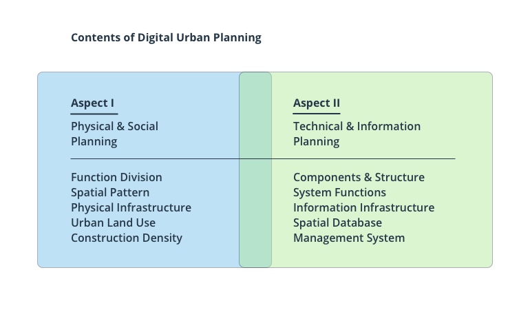
From the perspective of composition, it’s a duet of physical and technical planning. On the physical side, the process includes the city infrastructure itself along with its spatial attributes and functional departments of the city administration. On the technical side, it’s the vast ICT infrastructure, distributed databases, and a management system that ties it all together and interfaces with end users.
On the process level, digital urban planning is a complex, iterative process that constantly revolves around acquiring data from multiple sources (sensors, cameras, IoT devices, meters), processing it properly (conversion, validation, summarization, aggregation), and turning it into meaningful insights that end users can access through an online platform.
The key technologies that make digital city planning possible
Digital urban planning heavily relies on the concept of a digital twin. Digital twins are accurate virtual representations or copies of physical objects or locations based on data coming from vast arrays of sensors, cameras, and devices monitoring the physical infrastructure. Every digital city twin in existence is a medley of underlying technologies. Generally, these are the most important technological constituents of the digital urban planning process:
- 3D visualization, including AR and VR
- Cloud-based services that aggregate, process, and store relevant data
- User-facing portals and mobile applications
- Cybersecurity tools
- IoT infrastructure capturing and feeding data to multiple destinations
- Advanced GIS services
- Big data management and analysis tools
These and other relevant technologies are not used in isolation. There is a lot of interplay and cross-pollination between every aspect of the digital twin approach to urban planning. From building a complex and reliable communication network capable of withstanding high loads to properly managing huge volumes of incoming data, the process requires utmost attention to detail and a forward-thinking attitude at every step of the way.
As more innovations like driverless cars and fully autonomous, AI-based city management systems arrive, they will inevitably blend into the existing digital urban planning paradigm and be treated as its integral parts.
Digital urban planning in examples
Digital urban planning is becoming a reality for a growing number of cities around the world. Some initiatives kick off as 100% greenfield projects and have the advantage of being implemented from scratch. Some are examples of retrofitting of existing urban infrastructures to fit into the smart city paradigm.
Songdo in South Korea and Masdar in UAE are good examples of greenfield smart city projects gaining a lot of traction in the press and the industry in general. Both are young cities that were designed and built with smart elements embedded in their DNA, with a great deal of attention placed on accessibility for all, innovative architecture, renewable energy, and the overall appeal to its residents. The fact that all of the digital innovations were implemented in a top-to-bottom fashion ensures there are no functional bottlenecks and the entire system is scalable.
Coming from the same region, Singapore is one of the leaders of the smart city game with its outstanding Virtual Singapore program. A complete digital twin of Singapore, Virtual Singapore is a massive and highly detailed 3D model of the entire city intended for residents and organizations to take an interactive 360-degree tour around the city and run experiments based on the incredible amount of detail available in the model. The platform enables users to get down to such minute details as wall materials, area of particular surfaces, sun exposure statistics, and a lot more. With these powerful tools at hand, users can simulate the effects of new construction, traffic rerouting and population growth, and instantly see how they affect the existing urban environment that they live and work in.
In the US and Europe, smart city projects relying on digital planning tend to be implemented as retrofitting initiatives meant to resolve long-standing issues in the city infrastructure and eliminate bottlenecks. Palo Alto in California, for instance, uses a digital twin for the city’s parking lots. Real-time data is collected by a network of low-cost sensors, enabling drivers to locate free parking spaces on the go via a mobile app. Coupled with visual surveillance data from cameras and GPS tracks from vehicles, the digital twin also aids the city administration in planning roadwork and creating crosswalks.
Conclusion
As futuristic as they may seem, digital twins of entire cities are a new reality for companies involved in digital urban planning. In the future, a growing number of digital city transformation projects will be carried out using IoT components, smart platforms, and cutting-edge 3D visualization tools. Initial investments in ICT will be paid off by the increased effectiveness of all aspects of the city’s day-to-day operation. And with the extra bonuses of better ecology, broader accessibility, lower transportation costs, and substantially improved quality of living for residents, digital urban planning appears to be the most natural avenue for all new urban initiatives.
Intellias offers a wealth of expertise in building complex, interconnected IoT solutions and data processing systems, including smart city components and digital planning tools. For more information on the ways our company can contribute to your success on the market, please browse our website or contact us directly with questions.