Extreme weather events are the most severe hazard humanity is facing today, according to the Global Risks Report 2018 by the World Economic Forum. Rising sea levels, heat waves, and wildfires create unfavorable living conditions. It’s high time we paid attention to wildfire software and GIS fire maps development to diminish the impact of disasters and save thousands of lives.
Every year, wildfires destroy 35 million hectares (86.5 million acres), or around 1% of the world’s forests, and take dozens of human lives. In Portugal, a raging five-day blaze killed 64 people and injured 250 in 2017. In Greece in 2007, wildfires caused 80 deaths.
In California, the 2017 wildfires took the lives of 47 people. The next year brought even larger disaster: with 77 people killed and around 1000 unaccounted for, the 2018 wildfires became both California’s most devastating and its deadliest. Large tracts of the state were ablaze and at risk of becoming uninhabitable in future. Overall, since 2000, the United States has spent at least $1 billion annually on firefighting and recovering infrastructure after forest fires.
Number of fires and acres burned by wildfires in California

Source: Wildfires continues to be more devastating in 2018
Is it possible to solve this billion-dollar weather catastrophe that takes more human lives than hurricanes? What can help wildland fire management agencies defeat fires?
Today, firefighting is typically reactive, tackling fires as they arise. But it has to be predictive. Aware means armed, and we have to use weather monitoring solutions, wildfire software, and real-time data to forecast and prevent wildland fires.
How can fire management benefit from wildfire mapping solutions?
The consequences of global warming fuel long-burning wildfires. Research shows that an average temperature increase of 1°C annually would expand the median area burned by 400% or more in some types of forests in the Western United States.
Burned areas with a 1°C increase in global average temperature

Source: Climate Signals – Maps: Increase in median area burned for western United States ecoprovinces
As the temperature rises, precipitation and soil moisture levels change, leading to hotter, drier conditions that cause droughts and more intense blazes in particular areas. Right after record heat and dry summer and fall, the burning of 674,957 hectares (1,667,855 acres) in 2018 turned Californian landscapes into infernos.
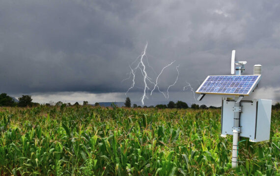
Meteorological stations already provide wildland fire management agencies with basic weather data, though it’s too primitive and isn’t enough for effective wildfire mapping. Rudimentary meteorology networks lead to fatal inaccuracy and erroneous decision-making. Firefighters need wildfire GIS networks for an effective fire management system.
How critical is fire weather data to wildfire mapping?
Fire agencies can’t combat wildfires without sufficient data: operations are always adapted to weather conditions. For example, understanding wind speed and direction and the possibility of rainfall allows firefights to prepare the necessary fire suppression resources and define which areas to evacuate first. However, finely spaced remote automated weather stations (RAWS) equipped with wildfire modeling software can help not only predict fire behavior but also define possible dangers to prevent fires from starting.
With wildfire modeling software and fire danger rating systems, firefighters can make consistent, fact-based decisions. China, for example, has successfully implemented environmental monitoring solutions for fire weather. Their national fire danger rating system has helped to reduce areas burnt by 90% since 1987.
Which data impacts fire danger ratings?
Apart from temperatures, fire danger observatories assess topography, fuel, and weather. Hourly weather inputs, fuel moisture levels, and topography prerequisites for strong winds help to indicate potential wildfires.
Fire danger rating factors

Only accurate and error-free information leads to the right decisions. Even minor changes in indicators affect wildfire mapping, so it’s critical to collect and process timely data for accurate estimates. Overestimation can cost fire agencies a fortune, while underestimation endangers lives, properties, and nature.
How to achieve fire weather data accuracy and reliability
Only a properly located and connected network of remote automated weather stations can improve the fire danger record and enable efficient wildfire software design. Unlike existing meteorological networks that don’t cover fire-prone areas and don’t gather specific information, purpose-built networks can capture minor precipitation changes and spot potential risks.
The World Meteorological Organization claims that automated weather stations can access high-frequency data, better identify extremes, and monitor data quality automatically. Forest Technology Systems (FTS) is the world’s leading provider of such weather monitoring solutions. Their stations are used by the top 50 government forest management agencies in the United States, Canada, and Mexico. Portable or fixed-site, these stations collect telemetry data and convert it into actionable insights about hazardous weather conditions to prevent ignition in fire-prone locations.
However, RAWS face the challenge of gathering data and making it accessible for instant analysis and measurement. To enable continuous data accessibility, SaaS solutions come in handy. Let’s see how exactly modern environmental technologies protect wildlands from fire disasters.
Developing wildfire software with fire danger rating systems: software-powered safety
Intellias has partnered with FTS to advance their wildfire software with weather forecast and monitoring systems by providing GIS fire maps. We’ve built a user-friendly portal with a mobile application that contains valuable telematics data obtained from hardware stations installed in distant, difficult-to-reach areas. This cloud-based data management system is easy to access and provides fire weather data on-demand, helping governments to monitor critical changes in real time.
With the help of APIs, secure protocols, and GSM modules instead of expensive satellite connections, we managed to connect remote stations and set up safe data transfer many times faster and cheaper. A complex web-based system collects information from station sensors and filters and configures data based on its purposes.
Additionally, the unified system network allows FTS to control and update their stations remotely. Lots of RAWS are located in dangerous areas. Since timeliness is crucial when it comes to wildfires, this saves precious time and resources on sending helicopters to faraway, risky sites. Intelligent analytics helps to monitor critical temperature or precipitation changes and take preventive measures accordingly.
Technology makes a critical difference for wildland fire management
Technological advancements coupled with global digitalization are usually considered a cause of environmental degradation. However, if used wisely, tech solutions can tackle critical challenges that the environmental field faces today.
First, technology can help to counteract the unpredictability of weather and help people to make timely decisions. As extreme weather events increase in frequency, the ability of technologies to provide accurate live data is crucial. Incorrect weather data can cost fire management agencies a fortune, while the planet loses invaluable resources and human lives. A dedicated fire weather monitoring network ensures more effective firefighting with less damage to ecosystems.
Working directly with FTS, Intellias has deep expertise in wildfire software development and telemetry data collection from various device sensors. Using data-based solutions, our experts help to optimize preparation time and resources, build fire danger maps, reduce damage from record-breaking weather events, and eliminate potential risks with specific forecasting methods.
Contact us if you’re considering implementing technology-powered environmental solutions or exploring the opportunities they offer to save the world from uncontrolled wildfires.