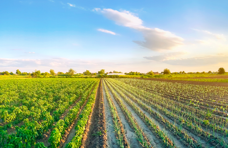
Modern agriculture has transformed into a high-tech enterprise that no longer resembles the American Gothic image. Instead of pitchforks, modern farmers hold drone controllers to monitor operations in their fields. GPS-guided tractors plowing fields with high precision are commonplace. However, the global demand for food continues to grow, forcing agribusinesses to keep up with demand spikes and growing pressure to produce more with less. In response, agribusinesses are seeking to pair GPS technology in agriculture with advanced tools in the pursuit of greater predictability and efficiency of resources.
Farms are becoming more like factories: tightly controlled operations for turning out reliable products, immune as far as possible from the vagaries of nature.

In this article, you’ll read about GPS in precision agriculture:
- How GPS enables the whole cycle of precision agriculture
- GPS for collecting agricultural data
- Analysis and planning with agricultural GPS systems
- Precision field operations with GPS guidance for agriculture
- Yield monitoring with agricultural GPS tracking
- Advanced mixtures of technologies with GPS for agriculture
- Sensors and IoT
- AI and data analytics
- 5G connections
GPS enables the whole cycle of precision agriculture
Getting a yield is like solving a complex multivariate algebraic equation. If a farmer does the math right, they can maximize field productivity. Otherwise, the entire season’s harvest may be compromised. Luckily, agriculture GPS tracking technology can augment the intuition of experienced farmers, allowing them to manage their fields with high precision. Let’s look at how GPS in farming brings value at every stage of precision agriculture.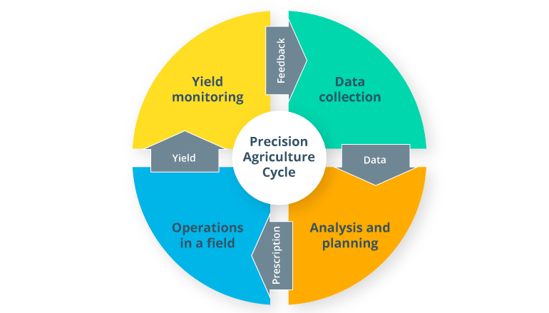
GPS for agriculture data collection
Field mapping
Determining field boundaries and navigating fields by relying on recognizable landmarks can work for small farms. On large farms, however, planning based on visual clues is not reliable enough. This is where agriculture GPS systems come to the rescue.
While inspecting fields in a tractor with an installed GPS device, a farmer can mark the coordinates of rocks, potholes, power lines, tree rows, etc. The farm GPS mapping readings can then be added to a field map to mark locations that the tractor must avoid or shut down seeding and spraying equipment while passing through. Also, you can create geofences to exclude lands that need to be left uncultivated and regions where farm animals may be grazing. This information helps to create precise field maps, which are very useful for planning and in-field GPS guidance for agriculture machinery.
Field scouting
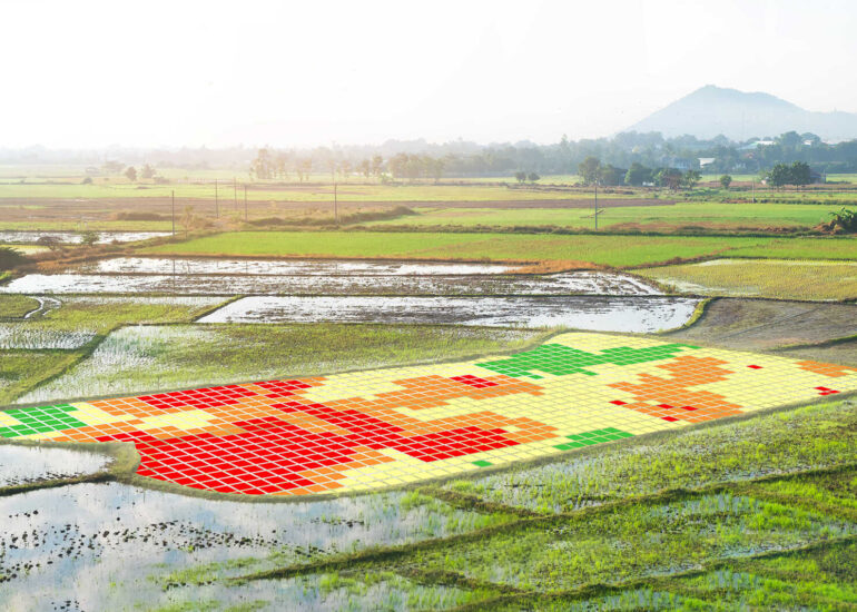
By compiling historical imagery and vegetation indices, mapping software can create a contour map showing fertility variations throughout a field. The software can then suggest farm GPS system coordinates of the most representative spots from which to take soil samples. Georeferenced samples help define causes of variable soil fertility, which might include topography, soil texture, soil nutrients, and moisture content. With this data, farmers can define homogenous zones and develop tailored management tactics for them.
Analysis and planning with agriculture GPS systems
Results of field scouting provide valuable data for creating a prescription map for the variable rate application (VRA) of fertilizer, seed, and chemical. Based on soil characteristics and planned yields, a prescription map shows the input dosage for every field zone. Powered by data from GPS, the agriculture VRA calculator suggests a higher level of input for areas where it adds the most value while lowering the dosage where it has less impact on yields. The prescription file can then be loaded to a tractor’s onboard computer, with VRA equipment enabling precise seeding and fertilizing.
Precision field operations with GPS guidance for agriculture
Agriculture navigation based on a custom field map enables tractors to plow fields precisely by following predefined tracks and avoiding geofences. Once a field has been plowed, GPS tracking data is used to place seeds accurately within furrows. As the applicator moves through the field, VRA equipment changes the concentration of an input based on the tractor coordinates and prescription map. Equipped with GPS navigators, tractors can operate in fields during fog, darkness, or heavy rain, thus reducing farmers’ dependence on weather conditions.
Yield monitoring with agriculture GPS tracking
Another use of GPS in agriculture is for monitoring and evaluating yields in different zones across a field. Located at the top of a grain elevator, a mass flow sensor continuously measures and records harvested crop weight. The measurements can then be correlated with GPS tracker data for yield mapping.
Since farming GPS systems track almost every action in a field, farmers can get valuable data for post-season analysis to calculate net margins for each field management zone. Through farm management software powered with geoinformatics and data visualization tools, farmers can assess the impact of applied technology and make informed decisions to optimize farming processes in the future seasons.
Advanced mixtures of technologies with GPS for agriculture
Sensors and IoT
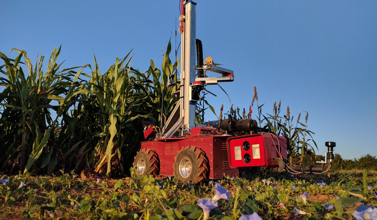
The more accurate the data you collect, the more precisely you can manage a field. Luckily, modern tools for acquiring agricultural data like a vertical farming solution or precision farming provide accuracy that would have been unimaginable just 15 years ago. IoT-powered sensors with GPS trackers can be installed on tractors for on-the-go mapping of various soil parameters such as texture, bulk density, mechanical resistance, draft force, moisture content, organic matter, nitrate content, and pH.
The sensor-based management of herbicides and other pesticides is another benefit of practical uses of GPS in agriculture. Sensors for weed detection vary from simple color deviation detectors to advanced computer vision systems capable of distinguishing crops from weeds and identifying weed species.
AI and data analytics
In precision agriculture, GPS systems produce a wealth of data that needs to be interpreted. Big data analytics can make sense of these datasets by structuring and categorizing them. Next, artificial intelligence algorithms can recognize patterns and provide insights helpful for increasing farm efficiency. This information may include recommendations for the best time to plant or predictions of pests and disease outbreaks.
In collaboration with the Swedish University of Agricultural Sciences, IBM has already leveraged advanced technologies in tandem with GPS to develop a prototype system for detecting late blight early. By combining near-infrared image recognition and climate data analysis, the app determines the likelihood of late blight in a field and uses georeferencing to provide GPS coordinates of its locations. Thus, farmers can remove or spray only plants that are infected before they spread the disease to the entire crop.
Source: Carnegie Mellon University
5G connections
The integration of sensors, computer vision, and GPS technology in agriculture enables autonomous equipment like drones and small unmanned tractors. Add to this high-speed connectivity with a central computer and you get fully automated control over crop health in real time. Imagine an autonomous vehicle carefully patrolling your field and recording images of your crops. These images are instantly sent to a data platform with AI-powered analytics for identifying weeds. If a weed is recognized, its precise location is sent back from the computer to the autonomous vehicle, which could then immediately destroy the plants as it moved around. With a fast 5G connection, communication between the GPS in tractors and the central computer has been proven to take just 25 milliseconds. Sensors and vehicle guidance systems also provide new opportunities for developing autonomous agricultural equipment like drones and small unmanned tractors.
M2M communication
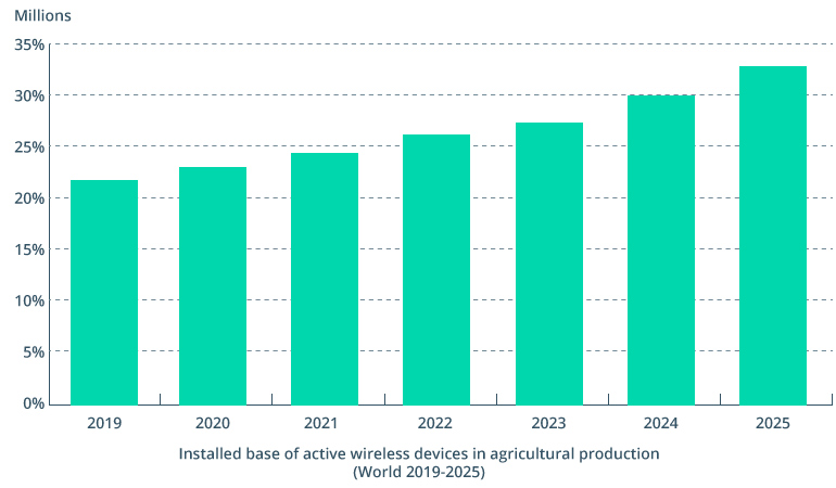
With the rapid advancement of wireless technologies and the omnipresence of GPS guidance systems, agricultural machines have evolved to the point where they can communicate with each other in the field. Machine-to-machine (M2M) communication has been attracting a lot of attention from the agriculture industry recently. The number of active wireless devices in agricultural production is projected to grow at a CAGR of 8.1% to 33.3 million connected devices by 2025.
Machine-to-machine communication holds big promise for automating many monitoring and control functions by enabling machines to know where in the field another machine is and what work it has done in real time. AI and ML facilitate communication between machines, allowing them to make their own autonomous choices. On top of that, IoT technology can bring together disparate systems into one unified connected ecosystem. Thus, machines can work as a team to get the job done in the most efficient way with no overlap. This means greater efficiency for farmers due to the optimal use of valuable inputs.
Final thoughts
For tech-savvy farmers, the use of GPS in agriculture is not an innovation. Yet GPS technology in agriculture serves as a launchpad for intelligent software powered by artificial intelligence, sensors, 5G, and the Internet of Things. With all this advanced technology, agribusinesses can increase and secure their yields by leveraging advanced planning, analysis, and forecasting capabilities. If agriculture is to continue feeding the increasing human population, farmers will require more sophisticated tools to meet the demand and stay competitive on the market.
Contact Intellias to discover more about incorporating GPS technology in agricultural solutions that will lead to higher yields and sustainable farming.